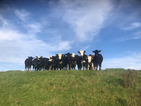
Just for a change a not-the-Peak-District South Yorkshire walk. Fishlake is a little village on the Don north of Doncaster. The first mile or so took me away from the river over farmland following what the OS map called the Thorne Rond Walk along mostly very muddy tracks passing north of Thorninghill Farm. Then I followed the Don north for a couple of miles. Hereabouts there is the river, then there is a strip of pasture beside it, then there is a man-made grassy bank to act as a flood wall with a path along the top, then there is a barbed wire fence, then there is the main footpath. Opportunities easily to cross the fence are few and far between. I found one as the nicest walking was on the bank without the same bank blocking any view of the river. All went well till I saw the cows grazing on the pasture ahead. Probably they are fine, I thought, but just to be safe I will walk the other side of the bank next to the fence so they won't notice me. They noticed me. I got back across the fence in some haste in spite of the barbed wire. As I approached Bank Hose I turned left on the road through Pincheon Green. This very straight little road has very little traffic but what traffic it had goes rather fast. The road took me to the New junction Canal I followed it south as far as near Wood End Farm. Then I took minor roads south looking to pick up the path shown on the map following the north bank of the looping old course of the Don. Important public service announcement. There is a path here and the ground underfoot is not nice. Avoid. A path began to exist where I rejoined the main river. After Stainforth Bridge I planned to follow the riverside path south of the road back to Fishlake but it was closed while some construction was underway so I followed the road all the way back. There is a reason the Peak District is more popular.
 RSS Feed
