

Jimmy Lenman |
|
![]() I parked, a little expensively, in Hutton-le-Hole and walked south down the main village street past the Ryedale Folk Museum and rather a lot of tea rooms to the Village Hall opposite which is a finger sign marking a footpath heading northeast. This goes round the back of some houses, past a bowling green and over a couple of fields to cross a stream. The last field before the stream contained a bull and some cows with young calves but they placidly ignored me and I them. After the stream there is a little woodland and soon one is on the road leading towards Lastingham. From here as far as the Millenium Stone just above Lastingham was ground already walked (see 36) leading pleasantly round the back of Camomile Farm. The OS map shows a right of way leading from the centre of Lastingham west to pick up the access road to High Askew and another from the Millenium Stone leading NW towards Hardtoft Bridge. But if you look closely at the 1.25,000 map you can see there is a path that links these two diagonally starting at the Millenium Stone and ending near High Askew that hugs the wall between the fields and the moors. I’ve been here before too (18). ![]() 
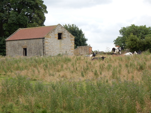
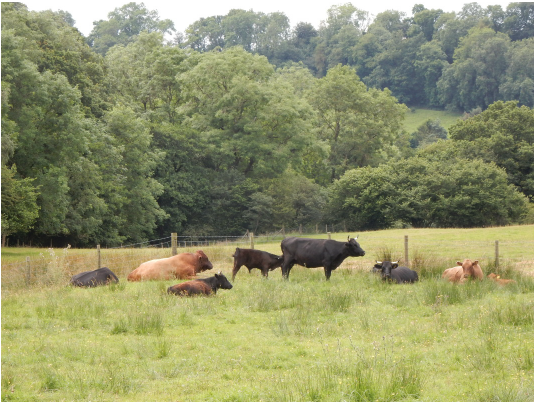
From here I headed south to near Low Askew where a right of way cuts a corner. I don’t think it is much used as the entrance was very overgrown with huge, inter alia, nettles. Ouch. I crossed a field of wheat then into a field of sheep. It’s a bit unobvious which way to go here but when you get to the river head right. The sheep here are a little territorial and instead of just fleeing mass together and chase you across the field. Except if you turn and wave your arms which sends off in a panic only to regroup and start again. Soon I was back on tarmac which I followed over a hill to Cropton Bridge. Just south of here a little before Cropton itself I turn off and followed the Tabular Hills Walk west then south down the attractive, leafy Low Lane glorious with summer flowers. Not to mention lots of not very old cow poo which left me wondering if and when I would meet its maker. Which at last I did, just at the point where I turned right to cross the bridge towards Appleton Mill Farm. A big herd, once again a bull, cows and calves but I didn’t have to get too close and again they left me alone. From here it was Tabular Hills Walk all the way home, past the Low Cross just before Appleton and a rather sadly dilapidated tennis court just after it. Then zigzagging back towards Hutton-le-Hole over high fields full of wheat and the occasional sleepy cow.
0 Comments
![]() The weather didn’t look promising. Wind. Dark cloud everywhere that could decide at any minute to make rain. So I thought just a modest walk today and why not Pike o’ Blisco since I’m based at the Old Dungeon Ghyll and can set off from the front door without needing my car. There are two ways up from here. One goes past Wall End Farm and then climbs up close to Redacre Gill to the east of Kettle Crag. The other goes through Stool End Farm then up Brown Howe to Red Tarn. I went up the former, down the latter and recommend both. The paths are excellent and well maintained. The start of the Redacre Gill path from the road over to Little Langdale is not signposted. It’s about five minutes walk after the point where the road starts to climb very steeply just before it turns left towards Side Pike. It’s pretty steep and hard work to about 500m. but the path is so well engineered it is like climbing a staircase. After 500m the angle eases and it doesn’t take long to the top from here. As you approach it there are three short scrambly bits up little gullies. Straightforward enough, they would have been still more so if they had been a little less wet. The last of them might feel slightly intimidating,especially in descent, to those of a nervous disposition who might prefer the Brown Howe path from that reason. The summit cairn is a splendid thing, large and unmistakable. Sadly I could see very little else in the grey soupy cloud that surrounded it. Tough guys get here and carry right on over Crinkle Crags to Bowfell but it was blowing a nasty wind up here and I wasn't feeling terribly tough today. The descent to Stool End is straightforward, again on an excellent path. A lovely wee hill. And it never did rain. ![]() I started at the Colosseum. From here you have to pay to get on top of the Palatine. There’s a ticket office just by the Arch of Constantine. I bought a ticket and walked up from here. The ticket is good for the Palatine Hill, including admission to the Museum, the Forum and the Colosseum, on any of which one could comfortably spend a whole day and another time I will. But I had other plans and just glanced at the Palatine Stadium and the House of Augustus, and crossed over to the Farnese Gardens and savoured the amazing view from here across the Forum. Round about this point it rained, suddenly, heavily and extremely briefly. I walked northeast across the Forum to the foot of the Capitoline Hill but there is no exit at this end and I had to double back a bit and exit onto the Via dei Fori imperiali and walk round to where a steep, wiggly road leads to the top of the Capitoline which is a rather grand square designed by a certain Michelangelo. I spent way too short a time in the Capitoline Museum but I thought I should at least say Hi to the wolf and her suckling babes. Only later did I realise that it was in this very same building, the Palazzo dei Conservatori, where, on 25th March, a famous treaty was signed by France, Germany, Italy, the Netherlands, Bellgium and Luxembourg inaugurating a new institution called the European Economic Community. The fact seems a little poignant now, given what was happening back in the UK this same day, 23rd June, 2016. ![]() Then I headed down the steps past the massive nude statues of Castor and Pollux and was soon round the corner in the Piazza Venezia. My next target was the Quirinal so I bore north and approached it up the big hill – the Quirinal is the highest of the seven - that is the Via della Ataria to reach the Piazza del Quirinale with its grand palace, home to countless Popes, kings and other bigwigs. Northwest from there down the Via del Quirinale past the park with its equestrian statue of Carlo Alberto then right down the Via della Quattro Fontane. Now I am on the Viminal, the lowest of the seven. Built up as it is, there is no real sense here of being on a hill at all. I walked round by the Piazza della Republica, the Teatro Opera, Termini Station and the Baslica di Santa Maria Maggiore down the Via Merulana and the Viale del Monte Oppio (Monte Oppio is the southern spur of the Equiline) past San Martino ai Monti to reach the Baths of Trajan in the Esquiline Park, hill number 5. Crossing this brought me back to the Colosseum where I had started. ![]() These are not big mountains but little urban nodules so I didn’t expect this walk to be very challenging. It was however now quite absurdly, soul-meltingly hot, unmistakably up in the 30s Celsius and it was getting to feel like hard work. I thought, I must stop and have something to drink but somehow I never did and kept going down the Via Labicana, right into the Via dei Normanni and past the St Clement Basilica and up the long, climbing Via dei Santi Quattro to reach the grand and imposing Piazza di San Giovanni in Latero, home to the Mother of All Churches, on the Caelian Hill. Number Six. I descended the baking, shadeless Via Satno Stefano Rotondo and the Via di S. Paulo della Croce to come out on the Viale Aventino at the west end of the Circus Maximus. Viale Aventino, the clue is in the name. Nearly done. Down the Via del Circo Massimo as far as the massive Massini Monument then up onto the Via di Santa Sabrina where I looked into the Giardino degli Aranci with its fabulous view acrcoss towards St Peters. Then down into the Via Marmorata where I found a little cafe and stopped for a much needed cold drink. Finally round the corner on the Lungotavere Aventino, not feeling brave enough to face Rome’s terrifying and overcroded public transport I hailed a taxi back to my hotel. |
|