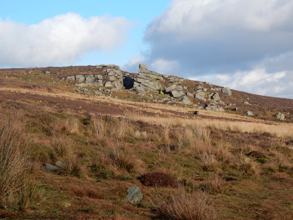
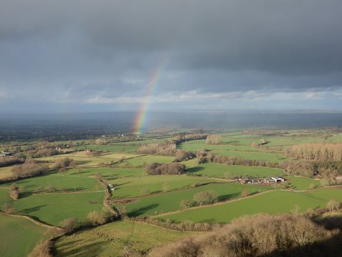
Bardon Moor is a big old grouse moor north of Skipton. A nice longish walk would link the three trig points on Halton Height, Crookrise and Thorpe Fell with the highest point, the Marilyn Cracoe Fell with its towering war memorial, maybe taking in the two reservoirs. I had something like this in mind for today but an evening in Leeds with an old friend to see Opera North’s beautiful production of Rimsky-Korsakov’s Snow Maiden ended with us sitting up boozing till four a.m. At my age you would think I would know better. Cut a long story short the end result was me parking my car by Embsay Reservoir and heading off uphill at about 2p.m. with the much curtailed plan of heading up Cracoe Fell and down it again. I followed the track along the edge of the reservoir to where it bends sharply right near Crag Nook. Here the map shows a path that heads of north, becoming a track and crossing the top of East Harts Hill. On the ground, but not on the map there is a signposted path, a bit further west, that heads off from the same bend and follows High Edge northwest to Crookrise. I took this path but did pay very close attention and managed rather early on to lose it. By the time I figured ourt I had done so, I was rather far away from it, off to the east on the wrong side of Lowburn Gill. Och well, I thought, I will just forget the path over Crookrise and head straight north towards East Harts Hill with a bit of luck picking up the more easterly path on the map. If the latter was anywhere to be found I never found it. I struggled over rough heathery ground over East Harts Hill passing deer Gallows Rock on my right, eventually meeting the path that crosses the moor from the top of the road near Halton Height to near Rylstone. 
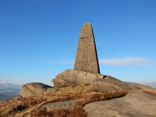
From where I was now to Cracoe Fell using the paths on the map would be a bit of a detour but I found a path of sorts not far away heading more or less straight towards my summit which I reach a little before 4, turning and racing the failing light back over Crookrise to the car park. I won. Just. (Before you protest, I’m a sensible fellow and carry a headtorch but it was satisfying not to need it.)
0 Comments
A Marilyn so small and insignificant the Landranger map doesn't bother naming it. I started at the car park at Stokesay Castle. Pay and display but not very expensive - flat rate of £1. The bvious way up is by Clapping Wicket. Instead of this I tried to follow zigzagging tracks/path marked on 1:25,000 map up through wood starting from 431812. This proved horribly overgrown in the lower parts and not recommended. Down by Clapping Wicket, a much better idea. A grey day with lots of low cloud ensured there was no view but as the top is in a big wood I don't imagine there ever is. Approaching Church Stretton on A49 from north, I turned right at the lights following sign for town centre. Then almost immediately I turned very sharp right again onto Essex Road. There is a signed footpath heads off on the right of this inbetween no. 56 and a tiny bridge over a tiny stream. I followed this over the railway and over the A49 and up to a crossroads. Here I took a lane off to the right signposted Caer Caradoc, 0.7 miles, 20 minutes. I was going a much longer way around but I’d say as a time from here to the summit that is a bit optimistic. After a bit the lane crosses a cattle grid. On the right just at this point there are, in very close succession, a footpath signed going off along the left hand side a of a field, a house, a track that informs us that it is “unsuitable for motor vehicles” and finally a signed footpath going off along the right hand side of a field. I wanted the latter. It’s a big field. Eventually the path, by now a track, leaves it for a wooded glade at the very foot of Caer Caradoc’s southern ridge where a footbridge off to the left is the direct way up. On the map the track carries on to pass something called Cwms Cottage, but I could see no sign here of human habitation, and an information board. Eventually I turned off very near the summit of the attractive strip of high grassy ground called the Wilderness, which I followed northeast for about a kilometre until a track led back down to the tarred road. I followed this over a crossroads and past the village of Enchmarsh, then took a track on the left which led to Hoar Edge which led to another tarred road which led, after a bit of wiggling, to the northeast terminus of the ridge that is the Lawley. From here it’s a beautiful walk up and over this pleasant grassy ridge with wonderful views of all the Shropshire Hills. It busied up too and I started to meet people – round by the Wilderness it had been pretty quiet. Eventually the ridge descends to Comley Farm. The last field was grazed by a herd of Highland cows. They were far away when I crossed but they had done their work churning up the ground and it was extremely muddy. Next objective Caer Caradoc. I was getting tired now and it looked very big. On through Comley and past the hairpin to a track on the left quickly left for a path of the left quickly left for a branch path on the right which is the direttissima way up Little Caradoc. Steep but not to the point of feeling too precarious. Less steep from there to the summit of Caer Caradoc itself. Thence a pleasantly gentle grassy descent as far as Three Fingers Rock and thereafter a brutally steep but mercifully short descent took me back to aforementioned footbridge and so home again. |
|